


| Home | Daily Reports | December | Day 254 |
|
Day 254, Tuesday, 8 December, 2009 Distance travelled – 73.4 km Ceduna to Haslam Although we write a diary each night it can be nearly a week before we write our web page entries. Our daily routine is such, (get up, pack up, ride, unpack, eat, sleep), that sometimes when we look back the days have merged into each other and it is hard to recall what happened just four days ago. So before we sit down in front of the keyboard we always review our diary notes and look at the photos from the day in question. Over the months we have discovered that one good indication on whether we had a good time is the number of photos we have taken. A lot of photos indicate lots of stops and that we had the energy and drive to get the camera out. If there are not many photos it is a good indication we did not enjoy ourselves and did not find time to admire our surroundings. Today we only have a handful of photos. As we left Ceduna we rode into a very strong head wind and for most of the day we found ourselves tackling the wind either head on or from the side. By lunch we had only reached Smoky Bay and if it was not for Denise I would have been happy to stay there the night. However, over lunch Denise persuaded me to push on for Haslam a small village 20km short of our proposed destination of Perlubie Beach.
When the jetty was constructed a horse drawn tramway was constructed to facilitate the loading and unloading of the ships. Other than the goods shed not much of the tramway remains. The community run campground is close to the old good shed and it was only after we had put up our tent for the night we discovered we had pitched it on the old tramway platform.
Zoom into the map and use the 'Satellite' layer to see our new location.
Everything is big down here! We found this giant blue bottle next to the Haslem Jetty.
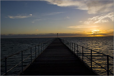
Haslem Jetty at sunset |
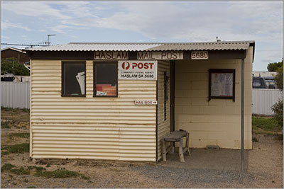 Originally known as Carawa Landing, Haslam’s beginnings date to the 1880’s when wheat farming started in the area. In 1910 a jetty was built to help with the loading and unloading of the ships. The jetty’s construction and the increase in shipping saw the town grow to include a General Store, Harbour Master, wheat buyers and infrastructure such as a local water supply. Today Haslam is much smaller with about 20 houses and the smallest Post Office we have seen on our travels, (it used to be the town hall's toilet block).
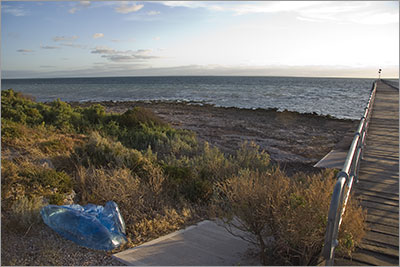
Home | Daily Reports | About | Contact Us | Merchandise | Site Map
© 2008 Mark Arundel