


| Home | Daily Reports | December | Day 265 |
|
Day 265, Saturday, 19 December, 2009 Distance travelled – 70.7 km Port Augusta to Port Germein
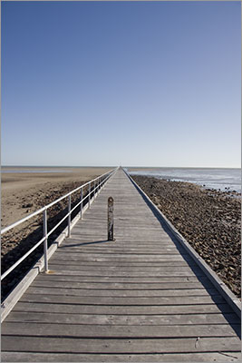
As we struggled against the wind to leave Port Augusta we came across a fellow riding north on his way to Darwin. He told us he only left Adelaide yesterday and the strong southerly winds had enabled him to ride nearly 300km in one day. We looked at him in awe of such an achievement, as we would be lucky to manage 90kms today. He was travelling very light and we wondered how he would manage to carry enough food and water for his trip north of Port Augusta. But 300km in one day is a record we will never achieve. After lunch the wind was getting stronger and the trucks were giving us a severe buffeting as they passed so we decided it prudent to stop each time one approached from behind. Twenty kilometres north of Port Germein we were pulling over to the left of the road and preparing to stop when a gust caught me, my front wheel hit the gravel and I went over the handlebars. At the time all I could think of was to fall left which I did and as the truck and cars passed I slid to a halt on the gravel. Both knees got a battering and as I stood up I watched my right knee begin to enlarge. Not wanting to give my knees a chance to stiffen up we decided to get riding again and for the next 10km it was a struggle to keep turning the pedals. We decided to stop at Port Germein for the night, ice my knee and see how stiff it was in the morning. We were to discover the only flaw in this plan was that the pub had sold out of ice! Port Germein is famous for its jetty being 1500 metres long and when built in 1881 it was the longest in the southern hemisphere. For many years the town served as an export hub for the area’s wheat and an average 100,000 bags would pass over the jetty each year. Today the town is a quiet hamlet bypassed by the highway and a very pleasant place to stop. The jetty is listed by the National Trust and is used by tourists and locals as a place to fish from. On a previous visit we did walk out along the jetty, but given our circumstances we were satisfied to just look at it from the beach this time. Zoom into the map and use the 'Satellite' layer to see our new location.
|
 The road south from Port Augusta is relatively flat and follows the coast most of the way to Port Pirie. With coastal views across the Spencer Gulf to the right and the Southern Flinders Ranges forming a border on the left there is a lot to look at. However, if the winds are blowing, the road’s proximity to the coast means you are very exposed and today was a windy day.
Home | Daily Reports | About | Contact Us | Merchandise | Site Map
© 2008 Mark Arundel