


| Home | Daily Reports | April | Day 27 |
| Day 027, Friday, 24 April, 2009
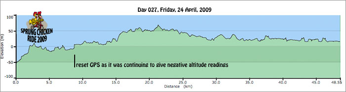
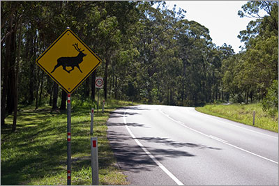
Distance travelled – 49.1km Aspley to Caboolture We left Aspley around 10 am to avoid peak hour traffic, and rode along Gympie Road for a short distance. We then followed a route along some quieter suburban streets that ran parallel to Gympie Road. It was interesting to see that there were still some very old houses on large blocks of land, with horse paddocks, in between much newer houses on smaller blocks. I would imagine land here would be worth a bit being only 15 – 20 km from the city. We rejoined Gympie Road when the suburban streets ran out and found that the traffic was pretty heavy. As we crested a small hill we were stopped by a fellow named “Eric” who wanted to check if we needed anything. He was also a keen cyclist and knowing how difficult it can be to get around Brisbane, he wanted to make sure we had the best experience. A nice touch to our previous day’s experience. As we were talking to Eric, Mark noticed that the altimeter on the GPS was giving negative readings, (-16m near the top of a hill). After a couple more km of such readings we made a quick stop to turn the GPS off and on again. With positive altitude readings we headed off again but we will need to talk to someone about the irregular readings we have been getting. Once we were on the Old Gympie Road riding was much more pleasant. Our route for the rest of the day roughly followed the train line. The only surprise was the warning signs for deer! We arrived at Caboolture at lunchtime and had our lunch in a park next to the oval, before setting off to find the Caboolture Caravan Park. Seeing as we had arrived early in the day and had plenty of time, we thought we would camp for the night. We knew that the caravan park was near the Bruce Highway, but after we had paid for our campsite we found out just how close it really was. The overnight camping area was right next to the highway, so much so that you could imagine a truck losing control and coming off the edge of the road and onto our tent. We hurriedly reconsidered our accommodation for the night and opted for a cabin, which was a little further (but not much) away. To make our stay even more uncomfortable, roadworks were being carried out on the highway right next to the park, with lights and generators operating throughout the night. After a night’s stay beside (on) the Bruce Highway we do not recommend you stay here. If you must stay in Caboolture use one of the motels in town or push on to another town with a campground. Zoom into the map and use the 'Satellite' layer to see our new location.
Warning sign on Narangba Road near Pine Rivers Golf Course
|
Home | Daily Reports | About | Contact Us | Merchandise | Site Map
© 2008 Mark Arundel