

| Home | Daily Reports | March | Day 364 |
|
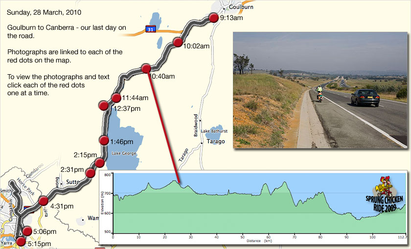
Day 364, Sunday, 28 March, 2010 Distance travelled – 114.3 km Goulburn to Canberra When we began planning our journey 18 months ago one of our early decisions was to ride anticlockwise around the continent. There were two reasons for this. Firstly the prevailing winds blow in that direction, and secondly, the towns on the east coast are close together which would allow us to gradually increase our daily distances and our fitness as we headed north. Even so, day one was always going to be difficult with 90kms to ride from Canberra to Goulburn. With fully loaded bicycles carrying enough creature comforts for 10 months away this was a distance we were not comfortable starting with, but at the time we could not think of any viable alternative. In the weeks prior to our departure we mentally prepared ourselves for the task knowing that the subsequent legs of our journey would be a lot more manageable. However, in the end it turned out we didn’t ride to Goulburn as commitments kept us at work longer than we had expected and we moved our departure point to Sydney. Today as we prepared to leave Goulburn there was no such hesitation about covering the distance. Rather we were concerned about covering the distance too quickly. As well as not wanting our journey to come to an end we had arranged to meet friends at Eagle Hawk at 4.00pm so they could ride with us into Canberra. As we left Goulburn at 9.00am we worked out we could be at Eagle Hawk at 1.00pm without too much effort, so we undertook to stop at anything that drew our interest along the way. Looking back over the last 12 months one of the most positive outcomes has been the building of our self-confidence. Having built a house ourselves, dragged up two children, started and run a successful business and now ridden a bicycle around Australia, we will definitely be looking for something else to challenge ourselves in the future. Below on our Google map we have created a timeline and linked photographs to 11 points along our route. To access the photographs and the story behind them click each of the red dots on our route. The timeline also shows where each of the red dots fall on the elevation profile for today. Zoom into the map and use the 'Satellite' layer to see our final location.
As we approached Collector we could see the end of the slower bitumen surface and the beginning of the faster concrete road. In the background you can see the escarpment that marks the edge of Lake George.
Map photos - 0913 | 1002 | 1040 | 1144 | 1237 | 1346 | 1415 | 1431 | 1631 | 1706 | 1715 |
Home | Daily Reports | About | Contact Us | Merchandise | Site Map
© 2008 Mark Arundel
